Introduction
Welcome to the Isle of Wight Area Group, a subsection of the Hampshire and Isle of Wight Branch of Butterfly Conservation
The Isle of Wight Area Group was set up in 2010. We organise
public walks to show people where to look for butterflies and
how to identify them and a few moth-trapping events suitable for
beginners and experts alike. In 2012, we will start some
organised monitoring of scarcer Isle of Wight species so that
the information can be used to assist their conservation. Any
records you make and send in on your own will be much
appreciated as there are many parts of the IOW that need better
coverage. Please send butterfly records to Paul Brock or add
them to the Hampshire and Isle of Wight sightings pages. Moth
records should be sent to Tim Norriss or Mike Wall.
Contact for IOW Area Group
Kay Shaw
tel: 07562974343
email: kay1950shaw AT btinternet.com
Pearl-bordered Fritillary monitoring
To help with Pearl-bordered Fritillary monitoring, please contact Stuart Read
tel: 07877 333734
email: s.jread AT btinternet.com
An introduction to the Isle of Wight
The Isle of Wight is the largest island in England. It is
roughly diamond-shaped and is 23.5 miles (37 km) long east-west
and 13.5 miles (22.5 km) wide north-south. The IOW has an area
of almost 150 sq. miles (380 sq. km) and 60 miles (98 km) of
coastline. It is separated from Hampshire by a stretch of water
called the Solent, which is approximately 30 miles long and 2-5
miles (5-8 km) wide.
The IOW has a population of around 140,500 (2010 data), most of
which is concentrated in the centre, north and east of the
Island. The county town is Newport, towards the centre. The
other main towns of Ryde, Cowes, East Cowes, Sandown, Shanklin
and Ventnor are all on the coast. Western and southern parts of
the IOW are more rural, with one small town (Yarmouth), villages
(the largest being Freshwater), hamlets and farmsteads.
Glanville Fritillary
© Ian Pratt |
Mottled Grey
© Sue Davies |
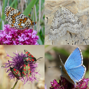 |
Six-spot Burnets
© Sue Davies |
Adonis Blue
© Peter Hunt |
The National Trust looks after 10% of the land and 51% of the
land is within the Isle of Wight Area of Outstanding Natural
Beauty. The ferry ports are at Yarmouth (passenger and car), Cowes
(passenger only), East Cowes (passenger and car), Fishbourne
(passenger and car) and Ryde (passenger only). The bus service
is run by Southern Vectis and buses run frequently in the summer
between the towns but some rural areas are poorly covered. A
train service, operated by Island Line Trains (part of South
West Trains), runs between Ryde Pier Head and Shanklin. See
below for further details. The IOW has a good network of public footpaths which can be seen here.
Weather
The IOW has one of the best records for sunshine in the south of
England and is warmer than many other places in the UK because of its southerly location and prevailing south-westerly winds.
Some areas are sheltered by high cliffs, for example Ventnor in
the south-east, which is renowned for its warm microclimate.
Despite the relatively small land area of the IOW, the weather
can vary quite dramatically from one place to another; this is
largely due to maritime and geographical influences. Coastal
areas are prone to sea fog through the spring and early summer.
This may linger through the early morning until the sun burns it
off.
Average maximum and minimum temperatures (in degrees Celsius) (Data from www.isleofwighttouristguide.com):
| Month |
Max |
Min |
| January |
8 |
3 |
| February |
10 |
4 |
| March |
16 |
5 |
| April |
18 |
7 |
| May |
19 |
10 |
| June |
23 |
13 |
| July |
24 |
14 |
| August |
27 |
16 |
| September |
23 |
12 |
| October |
15 |
8 |
| November |
13 |
7 |
| December |
10 |
5 |
Geology and landscape
The IOW is characterised by a great variety of geology and
landscape. A central chalk ridge runs east-west across the
Island and there is a second block of chalk downland in
south-east Wight. St Boniface Down is part of this second block
and at 241 m is the highest point on the Island. Lower-lying
clays, limestones and gravels occur to the north of the central
chalk ridge, with Greensand and Wealden deposits to the south.
IOW habitats
Coastal
High cliffs form where the chalk ridge meets the sea at either
end of the IOW - at White Cliff Bay and Culver Down in the east,
and between the Needles and Compton in the west. The chalk
downland above the cliffs supports an abundance of wildflowers
and good populations of chalk-loving butterflies and moths (see
under 'Chalk downland', below).
 |
Coastal slump
Photo © Peter Hunt |
The southern coast in particular is vulnerable to storms
crossing the Atlantic and rates of erosion are particularly
rapid along the south-west coast of the Island. The eroding soft
sand and clay cliffs of the southern coast between Compton and
St Catherine's Point slump down to the sea to form an
ever-changing series of grassy terraces or undercliffs. This is
one of the main breeding areas of the Glanville Fritillary and
Wall. At intervals along this coastline, small streams cut
narrow ravines in the soft strata and these are further eroded
by the wind to form what are locally known as 'chines'. Chines
have rough vegetation and steep sides and provide valuable
shelter for plants and animals, including butterflies and moths,
living in exposed coastal areas.
From Niton to Ventnor, huge landslides of harder rocks over
softer clay have occurred in the more distant past. The
undercliffs so formed are more stable than those in the
south-west of the IOW and have been built on, as at Ventnor. The
coastal area between Niton and Ventnor is called 'the
Undercliff' and that east of Ventnor to Bonchurch as 'the
Landslip'. These undercliffs are exposed to the sun and
protected from the cold northerly wind by the inner cliff and
have a Mediterranean-type climate. They provide ideal conditions
for butterflies of coastal habitats, including the Glanville
Fritillary, Wall and Clouded Yellow.
The north shore of the IOW is composed mainly of soft and
slumping clay cliffs and sheltered estuarine creeks and
harbours. The northern shore is more sheltered than the southern
coast and erosion is not as rapid.
 |
Tennyson Down
Photo © Peter Hunt |
Chalk downland
The unimproved downland of the central chalk ridge and the
outlying block in the south-east of the IOW support good
colonies of Adonis, Chalkhill, Small and Common Blues as well as
localised colonies of Brown Argus, Dark Green Fritillary,
Grizzled and Dingy Skippers and Green Hairstreak. Abandoned
chalk quarries provide sheltered butterfly havens, as at Afton
Down and Brook Down. Brook Down is well worth visiting for
Adonis and Chalkhill Blues and Dark Green Fritillaries, hundreds
of Chalkhill Blues can be seen on Tennyson Down in late
July/early August and Brading and Bonchurch Downs also have good
colonies of both Chalkhill and Adonis Blues.
Woodland
Most of the woodlands over 1 ha in size are north of the chalk
ridge. The mixed woodlands on clay soils in the northern half of
the Island hold good colonies of White Admiral, Silver-washed
Fritillary and Purple Hairstreak. Examples are Walter's Copse at
Newtown (National Trust) and Firestone Copse near Wootton
(Forestry Commission). Parkhurst Forest and Firestone Copse are
blocks of Forestry Commission woodland with waymarked trails and
car parks. The former holds the Island's remaining
Pearl-bordered Fritillary colony. The White-letter Hairstreak
occurs in the Newtown area (near the main bird hide) and at
Parkhurst Forest but needs a lot of patience to find.
 |
Headon Warren
Photo © Peter Hunt |
Heathland
There is currently only 70 ha of heathland on the Island but a
restoration project by the Hampshire & IOW Wildlife Trust is
trying to increase the amount, mainly by reclaiming it from
forestry, for example at Bouldnor and Brighstone Forest. Other
areas of heath are found at Headon Warren (between Alum Bay and
Totland), at Cranmore and at Bleak Down near Godshill. Ningwood
Common, a Hampshire & IOW Wildlife Trust reserve at Cranmore,
holds the Island's remaining Small Pearl-bordered Fritillary
colony. The Grayling may be seen at Headon Warren and in good
numbers at Bleak Down.
Farmland
The Wall may be seen on farmland tracks such as sections of the
Hamstead Trail between Brook Bay and Hamstead Point. Newly
arrived migrant Clouded Yellow, Small and Large Whites and
Painted Lady may be seen nectaring on flowers in wildlife strips
around fields and in crops of clover and Lucerne. On warm days
with a southerly wind, these migrants can be seen arriving in
off the sea and feeding on clifftop flowers before continuing
north. Butterflies that can be seen in profusion on the small
flower-rich meadows enclosed by dense hedgerows of the north of
the Island include Marbled White, Gatekeeper, Meadow Brown and
Small Skipper.
Ventnor "Butterfly Town" Walking Trail
Suggestions for discovering butteflies on a walk around Ventnor
are to be found in the Ventnor "Butterfly Town" Trail leaflet
that can be downloaded here:
Travelling to the Isle of Wight
The official site of Isle of Wight tourism can be found here.
Ferry links
- Wightlink
www.wightlink.co.uk
Lymington to Yarmouth (passenger and vehicle)
Portsmouth to Fishbourne (passenger and vehicle)
Portsmouth to Ryde catarmaran (passenger only)
- Red Funnel www.redfunnel.co.uk/en/
Southampton to East Cowes (passenger and vehicle)
- Hovertravel www.hovertravel.co.uk
Southsea to Ryde (passenger)
Bus service
Train service